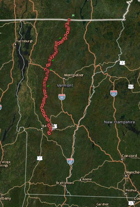
This was my second attempt at the Long Trail unsupported fastest known time (FKT). Unsupported means the runner/hiker must carry all supplies (food, gear, etc…) from start to finish without any assistance from anyone along the trail, and no drop bags along the way may be utilized. Water may be filtered or treated from sources along the trail.
After an unsuccessful bid in 2014, I knew I would eventually try again, but the timing was always a challenge. I started training again in 2015 with the intention of going for it that summer, but I quickly realized my head was just not in the game. In 2016 Olivia and I got married, so we were focused on the chaos and fun of wedding planning. I started training again in 2017, but injured my hamstring due to silly overtraining. 2018 and 2019 were dominated – in a good way – by growing Vermont Huts (my other outdoor passion and job), and the arrival of our son, Barkley. 2020 brought us the pandemic and a world of uncertainty.
So this would be the year to try again. Barkley is now a little over two years old, and Olivia is pregnant with our second child. I might not get another shot at this one for awhile. Below is my trip report:
Day 1, June 10: Canadian Border to Laraway Lookout – Approximately 42 miles
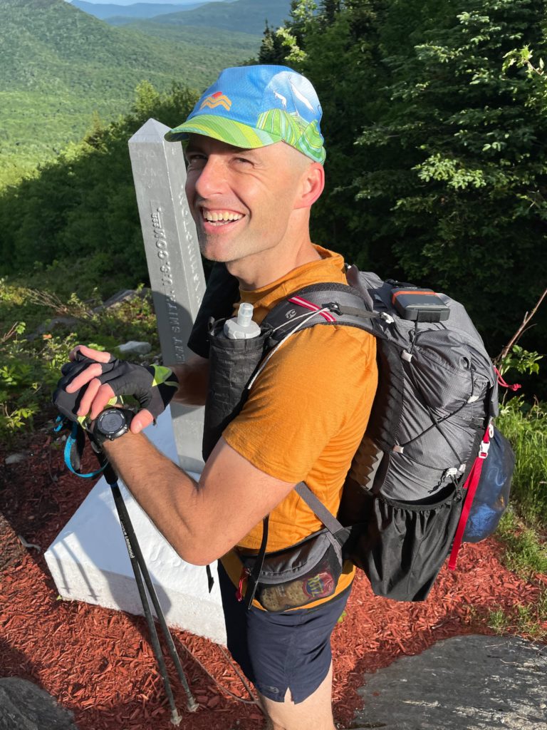
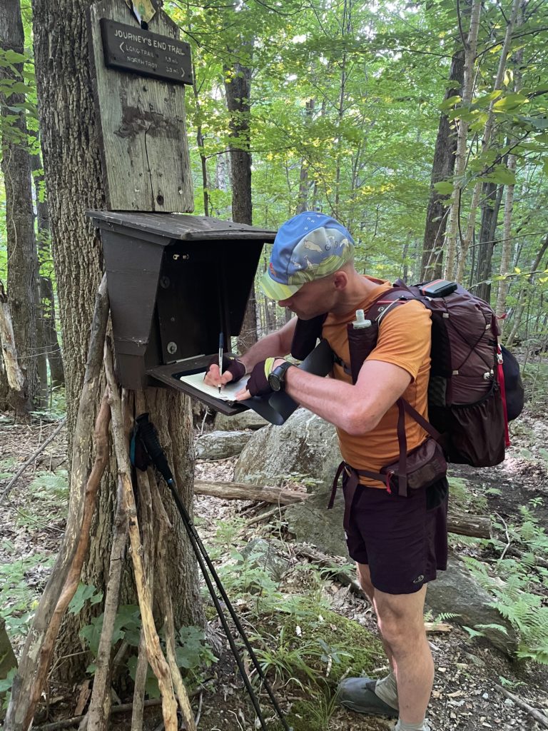
My friend Jeff drove me up to the Journey’s End parking lot and hiked in with me to the northern terminus of the LT. It was the perfect morning to be outside. Cool temps, blue skies, and next to zero chance of precipitation. I was nervous for many reasons, but I was mostly concerned about my left hamstring, which had flared up less than a week ago during my taper. I was super frustrated because training had gone so well this time around, and to have it crop up just before go time was a real downer. Luckily, it was a non-issue and seemed to vanish on the hike up to the terminus. Jeff had thru-hiked the AT a few years prior, and we chatted about some of his days on the trail. It was nice to have his company at departure.
Jeff snapped a few pictures at the border, and after a big hug and high-five, I was off at 7:07 am.
I had run this northernmost section of trail a handful of times, so I knew what to expect. I also knew that we had not received a ton of snow last winter, and rainfall amounts this spring were also not soaking, so I expected water sources to be low. I carried two 750-ml soft flasks up front, each equipped with a Salomon XA filter cap. I also carried an additional 500-ml soft flask in my pack, which I intended to leave empty and fill later down the trail for the push over the Monroe Skyline, as water sources between App and Lincoln Gaps are notoriously low regardless of rainfall.
Even before summiting Jay Peak, I discovered water sources were critically low, and I could not simply dunk my flasks and be on my way as I had done in the past. Instead, I was forced to use the backup 500-ml flask as the “dunker,” filling it up as much as possible (I could usually only get a quarter of it full) and then dump the water into the two larger flasks. This worked well enough, and fortunately water sources improved south of Hazen’s Notch, though they were still lower than I’d ever seen them.
After a quick chat with two guys on the summit of Jay (my first human interaction since starting), I reached Route 242 on schedule, and my next big climb would be out of Hazen’s Notch, up to the summit of Haystack Mountain. I’ve always been annoyed with this particular climb, mostly because the first mile or so is usually a sloppy mess. That was not the case this year – it was dry as a bone. Nice! (But maybe not so nice since water sources suffer. It’s a double-edged sword.)
After reaching the backside of Haystack I began to settle into a rhythm, and my mind settled as the worries of my hamstring blowing up slowly faded away. This was a big confidence booster.
The descent down Belvidere Mt. to Route 118 was tedious, as are most of the downhills in the northern section. You simply have to pick your way down and use your poles as much as possible to preserve your legs for the smoother terrain when you can actually open it up a bit.
I spooked a bear just before crossing 118, and I was once again amazed at how quickly those large creatures can sprint through the forest. It was out of sight in about three seconds. I wondered how quickly it could cover the Long Trail, should it ever desire a walkabout.
Climbing up Devil’s Gulch requires some attention to detail, as there are many ways one can roll an ankle or bust a leg in there, especially with a full pack. I took note of the fact that I could not hear the water flowing under the boulders as one normally can. Another sign of a low water year. Fortunately, I had just refilled my bottles at a healthy stream crossing about a quarter mile earlier.
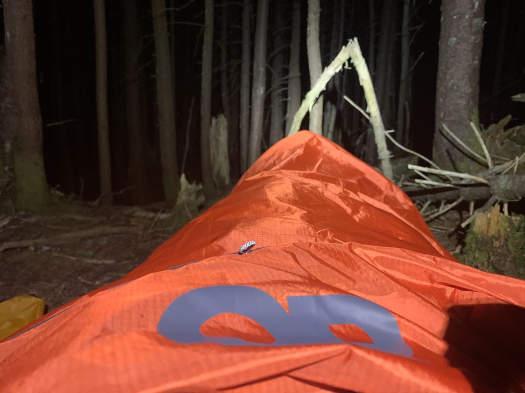
I reached Corliss Camp just before 9 pm. This was where I spent my first evening during my 2014 attempt. At that point the record was still held by Travis Wildeboer at 6d, 17hr, 25min – an amazingly fast time he put down in 2010 when gear was not nearly as light or advanced as it is today. Of course, the record had fallen by nearly a day since then, so I knew I needed to keep going. My goal was to summit Laraway so I could begin Day 2 with a downhill. I was starting to get tired, but I somehow made it to the summit in an hour, so I set up my bivy near Laraway Lookout at around 10 pm and hoped for a good night’s sleep. Sadly, that didn’t happen.
A note on the bivy: I used the OR Helium bivy for its quick setup time and its similarity in weight with some of the DCF solo tents from Zpacks and Gossamer Gear. I am pretty sure I regret this decision. While there is definitely some time saved with setup/breakdown, the bivy just didn’t allow for enough airflow. I had used it a couple of times before on weekend trips, but I must have been less wired on those nights, as I slept maybe 30 minutes on this first night. It could have been adrenaline or the bivy, but I believe if/when I try again, I’ll go with a tarp + bug net setup.
Day 2, June 11: Laraway Lookout to south of Bolton Mountain – Approximately 38 miles
I was moving by 4:19 am, feeling frustrated with my terrible night’s sleep. I wondered how this would impact my day, but I started to feel good after I crossed Codding Hollow Road and the sky began to brighten. My legs felt good. Today would bring what I consider to be the most technical stretch of terrain on the trail. Whiteface, Madonna, Mansfield, and Bolton all have challenging ascents and descents, which is why it’s so important to hit them in dry weather if you’re going for speed. I was lucky to have good cloud cover with no precipitation through this segment.
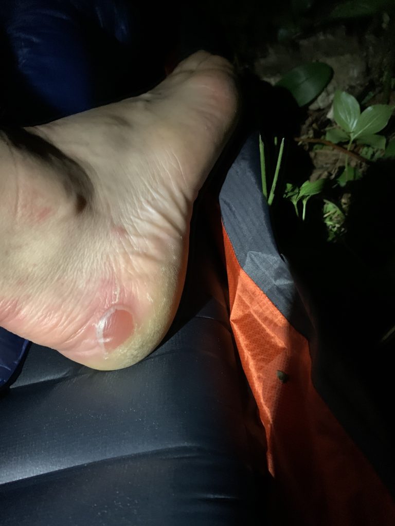
The climb up Whiteface is long. It is nearly as defeating (maybe more so) as the climb up Camel’s Hump, but with fewer views and less stimulating terrain to occupy the mind. That said, it’s a beautiful approach once you make it off the logging roads and into Bear Hollow. The wet conditions I had grown to expect over the years were again nowhere to be found, but water sources were still in decent shape through this stretch. I began to notice hot spots on the upper outside of both heels. This was a bummer as I generally do not blister, especially in dry conditions. Fortunately, they were located in areas that did not impact my gait, but simply inflicted pain. These would remain mostly tolerable for the duration of the trip.
After summiting Whiteface and scrambling down the initial descent, I took a brief stop (probably should have been shorter) at the Whiteface Shelter. I was pumped to have that climb behind me, and I started off toward Chilcoot Pass and the short, yet steep approach up Madonna.
I know the word “technical” gets thrown around a lot, but the section between Madonna and Sterling Pond is seriously a labyrinth of roots and rocks that are trying to swallow your feet and ankles at every step (OK, this is honestly large majority of the northern section, but this particular little stretch takes the cake in my book). Even on day hikes/runs through this section I struggle to move quickly, so it’s worth it to just take your time through this bit, pay close attention to footing, and accept the fact that even though you’re moving downhill, you’re not really going any faster than if you were climbing.
Sterling Pond was noticeably low, and as I dunked my flasks for a refill, I spotted a guy around my age sitting on a rock about 100 feet away from me. His face was staring down at his phone the whole time I was there – maybe three to four minutes. I hope he was simply referencing a map and not scrolling through his social feed. Bleh.
Feeling irrationally annoyed at this person’s lack of interest in his natural surroundings, I moved on in haste for the quick climb before the descent down to Route 108. More roots, more rocks, but I had run this section at least a dozen times, so I embraced the downhill and used my poles as much as possible to preserve my legs.
After crossing 108, I began the approach up Mansfield. I thought back to 2002 when I first climbed Vermont’s highest peak with some college friends from UVM. This mountain has played a huge role in shaping my love for the Green Mountains. I have witnessed myriad sunsets and sunrises from its summit, proposed to my wife at Taft Lodge, skied its backcountry for the better part of two decades, and run its numerous side trails to create some of the most exciting day loops you can find in New England. I have stood on its summit every month of the year. For that reason, the climb was easy. I used those positive memories to carry me up the final scramble and over the summit before beginning the long descent to Taylor Lodge. Again, dry conditions here are extremely beneficial on the ridgeline.
I reached Taylor Lodge at around 6:40 pm, about two hours earlier than I hit it back in 2014. This was also where I stopped on the second day back then, but with plenty of daylight and a goal of being south of Bolton before I went to bed, I began the climb in hopes of reaching the summit before sunset. This stretch of trail always beats me down. I should one day visit it on a fresh set of legs so I can experience it in a different state of mind, but I always seem to hit it at the end of a really long day, and it’s not fair for me to pass judgement on it. After all, it’s a beautiful and remote section of trail (only saw two hikers here), and the view from Puffer Shelter looking north is one for the books.
I reached Puffer around 8:45 pm, used the privy, and was on my way for the final stretch to the summit. I turned my headlamp on just before reaching the top, mostly satisfied with my progress, but I was growing tired, and the poor night’s sleep was finally catching up with me.
I intended to continue on until 11 pm or so, but by 10 pm my pace had slowed as I picked my way down the rocky descent, so I began searching for a spot to make camp. I located a decent flat spot off trail, got set up, repacked my food supplies for day three, checked in with loved ones, and hoped for a better night’s sleep. In hindsight, I wish I had stuck to the plan and continued on for another hour.
Day 3, June 12: South of Bolton to north of Lincoln Gap – Approximately 42 miles
I slept a bit better the second night, waking up only twice after some difficulty passing out. My alarm was set for 3:40, but I was awake at 3:30, so I decided to pack up and get moving. By 4:05 am I started a slow jog down the mountain. It is nearly 10 miles from the summit of Bolton to Route 2, most of which is downhill. This is a blessing and curse, of course. One can really open it up after Buchanan Shelter, but if you get too carried away, you’ll blow up your quads and ruin them for the true cruising terrain south of Lincoln Gap.
I did my best to walk that line – letting my legs stride out on some of the gentler downhill pitches, but reining it in and using my poles to assist with the descent on the steeper sections. After all, my pack was still relatively heavy, and I learned in 2014 what this descent can do to you if you’re not careful (I was trying to move too quickly in wet conditions when I slipped and tweaked my knee back then).
It was a relief to hit Route 2. My legs needed a break from the never-ending downhill, and the flat road and field walk before Bamforth Ridge was mostly welcomed, as I could turn off my brain a little bit and not focus so much on the placement of every single footstep.
Prior to the reroute, the LT simply followed Duxbury Rd. to the Bamforth Trailhead. While it’s nice to get off the road for a bit and away from speedy drivers, the tall grass of the unmowed fields was covered in dew, and after about 100 feet, I was drenched from the waist down. I had made it 87 miles with completely dry feet, so I couldn’t complain too much. I passed some chickens and a relatively aggressive large white dog – luckily inside the electric fence with the hens – before popping back onto Duxbury Rd. for the last section of pavement before the long climb up Camel’s Hump.
Bamforth Ridge can break you. It’s the most vertical gain you’ll find in any continuous climb on the LT, beginning at about 330’ above sea level and climaxing at 4,083’, or about 3,753’ of climbing from base to summit (not including the undulations along the way). For perspective, Jackson Hole Ski Resort has a vertical gain of 4,139’ from the base to the summit of its tram. The next time you hike Bamforth Ridge, consider the fact you’ve climbed nearly the equivalent of one of the greatest ski areas in the world, and give yourself a pat on the back! Bamforth or Bust, baby!
I reached the trailhead at about 8:10 am and set a goal of reaching the summit by 11:30 am. Definitely not blazing speed, but a sustainable pace. Since it was a Saturday the trail had a fair amount of hikers on it. I learned the water sources weren’t particularly terrible, which was welcomed information as I was still a bit nervous from the low sources north of Hazen’s Notch.
Somewhere south of the Bamforth Ridge Shelter I ran into a trail runner on his way down – Joe from Milton, VT, I believe – and we chatted a bit about gear. He had great energy and an amazingly positive attitude. He wished me well on my attempt, and I did the same for his safe descent. His energy stuck with me for awhile, and it was a reminder of the fact that, while I love the isolation of being in the forest, I crave human interaction more than I’d like to admit. Indeed, Joe from Milton restored my faith in humanity after my non-interaction with the cell phone dude at Sterling Pond (sorry cell phone dude, you’re on my SL).
I played leapfrog for a bit with a nice guy who was out for a day hike up Bamforth. We chatted for a bit, and I learned he also lived in Stowe. Unfortunately, I’m blanking on his name. We said farewell about 0.7 miles from the summit.
The summit of Camel’s Hump was predictably crowded at 11:30 am. Lots of folks out enjoying the perfect temps, calm breeze, and quintessential Vermont views. It was a perfect day to be in the mountains. I found an open rock spot and plopped down to change my damp Darn Tough socks out for some dry ones and enjoyed a quick snack (snack is not really the best term as it was simply one of my standard 30-minute feedings). Two women nearby asked where I was coming from, so I told them my story. I believe their names were Kayla and Evi (uncertain of spelling). One lived in Brooklyn and was visiting the other, who lived in Burlington. Both were super nice and seemed sincerely interested in the whole concept of an unsupported FKT. After a few minutes of chatting I said farewell and encouraged the Brooklyn resident to ditch the city and come to the Green Mountains to be with her friend (nothing against Brooklyn, of course).
Picking my way down Camel’s Hump, I reflected on the significance of having that long climb behind me. My legs felt good, my feet were in OK shape (save for those two blisters, which were no doubt growing larger), and my mind was sound, albeit somewhat tired.
I refilled my water bottles at Montclair Glen Lodge and began the quick climb up Ethan Allen. I was looking forward to the views from Burnt Rock, which are alway spectacular on a clear day. Somewhere between Ethan Allen and Burnt Rock I ran into two GMC volunteers who were out doing trail work. One of them let me know of a “strange crew” that was gathered at Cowles Cove Shelter with a crazy dog. Perfect, I thought. I’ll fit right in!
I was able to jog some sections between Ethan Allen and Burnt Rock, and after the relatively technical descent toward Cowles Cove, I was able to break into a steady jog/run until reaching Birch Glen Camp at 4:10 pm (the Cowles Cove crew was nowhere to be found, which was a bummer because I was looking forward to some weirdness on the trail).
Birch Glen brought back sad memories from my 2014 attempt. During that unsuccessful bid, it rained on me from Taylor Lodge to Birch Glen, I tweaked my knee coming down Bolton, and I arrived at this point hobbling, wet, and feeling defeated. But not this time. I was on schedule and feeling excited to cross App Gap in good spirits with healthy legs.
The climb out from Birch Glen to Molly Stark is rather steep, and it’s a bit of a buzzkill since you’re so close to App Gap. All I wanted to do was move beyond the point where I came off the trail in 2014. Finally, at about 5:30 pm, I crossed App Gap and began what felt like a bit of a time warp across the Monroe Skyline.
To be on this section of ridgeline at sunrise or sunset is especially magical. But before I get too romantic, let’s talk about the water situation here. Back at Birch Glen, I filled up both soft flasks, and I filled my emergency “backup” flask up ¾ full (about 375 ml). I decided to try and refill again at the Theron Dean shelter, where I found a small group of campers settling in for the night. They informed me the water source was dry, but I decided to try my luck. I bushwhacked down toward the unreliable stream to confirm what they had told me. It was dry, and I only had about 750 ml total remaining. I suspected the rain barrel further down the trail at the top of the ski lift was also dry. Nonsense, I thought. This little stream must have water!
I bushwhacked another 40 feet or so downstream and found a tiny oasis in the form of a little pool of water no larger than about 10” diameter and 1.5” deep. It was slowly being fed by a meager trickle of water. I again used my backup flask as a dunker and refilled each 750 ml flask as much as possible. This process of hunting for and refilling water took a painstaking 20 minutes or so since the mini oasis took awhile to refill after each dunk, but it was critical, for the rain barrel was, in fact, dry, and the next water source was several miles away.
So, back to the romantic time warp. I’m not sure what happened over the next nine miles, but the combination of mental fatigue and distracting views of the sunset over the Adirondacks must have slowed me down. I had expected to cover the roughly 11.6 miles between App Gap and Lincoln Gap in around four hours, with the goal of being south of Lincoln Gap for my night three camp. Not so on this occasion. My body did not hurt, but my head was growing tired. It seemed as though the poor sleep on night one was catching up and slowing me down.
I reached Lincoln Peak around 9:30 pm and stumbled upon a couple who was spending the night up top. They had music playing, cold beers, and all the things I wanted to enjoy in that moment, but I told them I needed to continue on toward Lincoln Gap. I desperately wanted to begin my final descent, but I still needed to get up and over Mt. Abe.
After the summit, I slowly picked my way down Mt. Abe and passed Battell Shelter at about 10:50 pm. I wanted to keep pushing past Lincoln Gap, but I decided to get a good night’s rest. At 11:15 pm I set up camp about a half-mile south of Battell Shelter, mentally tired but in good physical shape.
Day 4, June 13-14: South of Battell to Governor Clement Shelter – Approximately 58 miles
I slept well and woke up feeling strong at 3:35 am. Thank goodness. I took stock of my food and discovered I had plenty since I was unable to eat as much as I had planned in the evening hours, so I tried to eat more than my allotment the first few hours of the day. After some reshuffling of gear and food, I was moving shortly after 4 am.
I got into the habit of yelling “Good morning!” to all the animals as I started each day. I mainly wanted to avoid coming upon any large animals like bear or moose. I also sing lots of Tom Petty and Pearl Jam during the early morning and late evening hours for the same reason – while these animals are generally timid and afraid of humans, I’d prefer to let them know I’m in the area vs. silently rounding a corner and bumping into one.
The difference in terrain south of Lincoln Gap is so refreshing. I knew from previous training runs to expect a gentler and less rocky trail, but it sure felt good to experience it after three days of the crushing northern section. It was as if a magical rock sweeper had come through and removed 80% of the rock, leaving only the occasional spell of tricky spots to remind you that you were still on the Long Trail. I thanked this magical rock sweeper out loud on multiple occasions.
As expected, my pack was noticeably lighter on day four. That, coupled with the fine work of the rock sweeper, allowed for an improved pace and growing level of confidence. While I was a few miles behind my daily goal total, I was still on FKT pace, and the big climbs were a thing of the past.
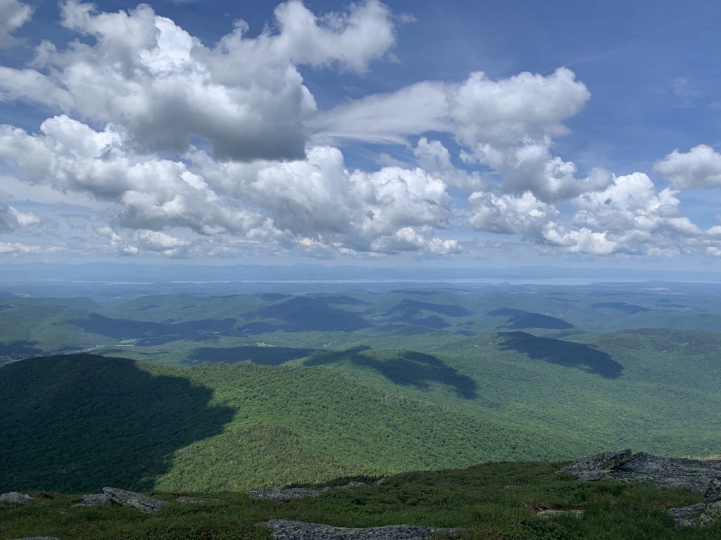
The Breadloaf Wilderness is one of my favorite sections of the LT. It’s remoteness, forgiving terrain, and occasional glimpses of the surrounding landscape create an enchanting feeling even while pushing hard. A few years ago, while on a training run through this section, I witnessed a moose plunge into Skylight Pond as I departed Skyline Lodge. Today I would only use Skyline for its privy.
It was another beautiful day, and I was thankful to have four straight days of perfect weather. It’s hard to get that in Vermont in June. I made it to Middlebury Gap around 11:30 am. I knew things got even mellower after Brandon Gap, so I did what I could to preserve my legs. At this point my food plan took a bit of a hit. I was consuming roughly 100 calories of food every half hour to maintain a steady level of fueling, and my gut was able to manage the diet of Ritz Peanut Butter Crackers, UnTapped Maple Syrup, Pro Bars, and Justin’s Almond Butter just fine. Without providing TMI, my bowel movements were regular.
However, on day four, the almond hazelnut butter I had been consuming every two hours as part of my rotation grew intolerable. It was not causing any stomach discomfort, but the taste and texture of it became repulsive to me. I was only able to take small squeezes of it, dilute it with water as much as possible, and then force it down. Once down, it was fine, but getting it there took serious focus, so I began to replace those feedings with maple syrup or crackers.
My first bit of knee pain set in while descending to Sucker Brook. It was to be expected at some point due to the strain placed on the patellar tendons while going downhill, so I took three ibuprofen at the brook. The good news was that I was pain free on the climbs, and by the time I was descending Mt. Horrid the ibuprofen had started doing its job. This was the last I would experience any type of knee pain.
By the time I reached Brandon Gap I had given up on the almond butter, which wasn’t the end of the world since my other food items would provide just enough fuel if I was able to finish in about 5.5 days as planned.
Somewhere near Telephone Gap I ran into an employee from Outdoor Gear Exchange who had helped me locate some last-minute items a few days before the start of my attempt. Vermont is such a small state. She and her partner were out running from Route 4 to Brandon Gap. Even though my pack was getting lighter by the hour, I was jealous of their running vests. So light!
At this point I saw a sign that said “Route 4: 12.7 miles.” It was about 6:40 pm, and I figured I could cover that ground in about 4 hours since it was mostly downhill. Except it wasn’t. What I failed to remember were two decent climbs – one up to Rolston Rest, and another up to Tucker Johnson.
I heard gunshots in the distance just before sunset, and I started to get an eerie feeling as I approached Rolston Rest. I was approaching the former spot of the South Pond Hut, a cabin that was to become part of the Vermont Huts network but was torched by an arsonist a few years ago. It was a tragedy, and I think my mind was simply playing games on me after dark. I refilled my water at Rolston and continued on with the determined goal of crossing Route 4.
I reached Maine Junction just before 11 pm. I thought about stopping here, but Route 4 was only a mile away, so I pressed on in an effort to put more distance between Jeff Garmire’s current FKT.
I crossed Route 4 at about 11:20 pm. I made my way in a bit to get away from the noise of traffic before sitting down to assess the weather forecast. I knew from checking earlier in the morning that rain and thunderstorms were predicted early Tuesday and expected to continue into Wednesday. I opened my weather app and discovered the forecast had deteriorated. Rain would begin around 2 am in the Killington area, followed by t-storms beginning around 5 am.
I had a decision to make: set up camp here, sleep for a couple hours before starting a 3 am climb and risk being near the summit of Killington as the storms rolled in, or continue through the night and get off the mountain before anything severe hit. Being on ridgelines during thunderstorms is not something I particularly enjoy. I have only been in that scenario twice – once on Mansfield and another in the Tetons. Both were extremely stressful situations, and I consider myself lucky to have not been injured or worse. You can move quickly through the mountains, but not faster than lightning.
I decided to push through the night, make camp on the other side of the mountain, nap for a couple hours, and assess the weather situation there. After restocking my food pouches, I began the march up Killington at midnight on June 14.
What happened between here and Governor Clement Shelter was equally beautiful and terrifying. As I approached Cooper Lodge around 3:20 am, the wind picked up a bit, but the rain had not started. I considered this a victory. About five minutes later, the entire left side of my left foot was drenched. WTF? It’s not raining yet, and there were no puddles. I was genuinely confused. I then took a few more steps and felt the pain of a burst blister. One of the blisters that had formed on day two had finally given way and spilled its contents.
I removed my shoe and sock, assessed the situation, and located my duct tape from my pack. I fashioned a patch by folding the sticky side of the duct tape together. I then ripped off two other pieces and adhered the patch to my foot. Feeling satisfied with my field work, I continued down the trail with minimal pain at the blister site. Time to hustle, I thought. The weather would be rolling in soon.
The next hour was slow going. I was mentally tired, and the level of focus required to navigate this descent was not something I possessed. A funny thing happened around 4 am. I began to sense there was someone walking with me, almost guiding me down the mountain. I forced myself to remember I was most definitely alone, but still the feeling remained. Clearly my head was going to strange places. I am not a religious person, but if it was the spirit of my mother who passed away in 2019, I would endure a thousand restless nights to feel her presence again.
I felt the first drops of rain around 5:00 am. The wind continued to increase, and I heard a few branches snap from their trees on either side of the trail. Around 5:45 the first crack of thunder rolled through. It was distant, but I knew it was approaching quickly based on wind speed. The spirit – or whatever it was – vanished, and I snapped out of my state of delirium. Adrenaline took over, and I began to run, not jog, down the mountain.
The rain intensified to a downpour, and thunder grew more frequent and closer. The wind grew stronger. I thought of my son and wife. I was pissed at myself for not making it down to a safer point sooner, and I broke into a full sprint. I bounded over wet rocks, feet seemingly hovering over the ground. The sky was still too dark to turn off my headlamp, and it’s a miracle I did not roll an ankle. Maybe the spirit was still guiding me.
I finally reached the stretch of gravel road leading to Governor Clement Shelter. Here I continued my sprint for what I believe was another mile or so before seeking refuge in the shelter. Three people were still asleep when I arrived around 6:45 am, and an AT thru-hiker popped into the shelter about a minute after me. Two minutes later, a flash of lightning lit up the sky, followed immediately by a loud crack of thunder that shook the ground and shelter. I was relieved to be in a safe spot.
At this point I was resolved to pull the plug. I narrowly escaped the wrath of Mother Nature, and the forecast indicated more was on the way where I was heading. After waiting an hour for the storm to pass, I followed the trail to Upper Cold River Road. I was able to confirm the forecast one last time: a 70-80% chance of thunderstorms where I was heading. I made the difficult decision to walk off the trail to North Shrewsbury, a few miles down a dirt road as the cold rain continued to soak me. I would then wait for a pickup from my father-in-law as I enjoyed a delicious homemade quiche and brownie from Pierce’s Store. (A big thank you to the employee who kindly let me into the store many hours before they were open. Should you ever be in the area, I highly recommend a visit to Pierce’s.)
My second attempt was finished.
Afterthoughts
It’s natural to wonder what might have been if I had simply hunkered down awhile longer and slept for a couple hours on the south side of Killington. Aside from those blisters, my body was in fine shape, and a bit of sleep would have done me right. I go back and forth, but I continue to believe I made the right call.
I simply love my family too much to risk not seeing them again and, while lightning strikes and getting smashed by a tree are unlikely, the odds go up when you still have to wander through the forest for another 94 miles. While I badly wanted this to be my last attempt at the FKT, Mother Nature had other thoughts, and I didn’t want to question her motives.
Maybe the storms would have only brought rain. Maybe I had already endured the worst of it.
Only the mountains know.